Advanced computer simulations are important tools that help us better understand hydrologic phenomena like rainfall-runoff response, groundwater hydrology, etc. However, building a hydrologic model instance to simulate a watershed requires properly assigning rainfall runoff catchments to street inlet or manhole structures, which typically demands a tedious manual process that takes up the majority of the time spent modeling.
But what if there was a tool that provided simplified access to the runoff catchment delineation process? Join Stormwater University for this educational webinar as speaker Prasanna Dahal, Water Engineer at Arcadis, introduces a prototypical ArcGIS tool that does just that!
The tool is derived under the assumption that—by updating the existing standard terrain delineation process to reflect a) the existence of houses, streets, and other civil structures and b) roof stormwater redirection practices—the runoff catchment delineation process can be automated. It then makes use of ArcGIS commands to delineate the runoff catchment. The final product is a polygonal output shapefile that has a one-to-one relationship with the input inlet/manhole shapefile.
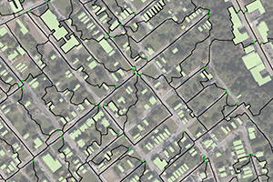
This course will cover a case study of a project in Pittsburgh, Pennsylvania in which the tool assigned 1,936 rainfall catchments to the same number of input inlets over an area of 2,872 acres. It will also introduce approaches taken to improve digital elevation models (DEMs) and current terrain delineation.
Learning Objectives
By participating in this webinar, attendees will:
- Understand the process of rainfall runoff in an urban setting
- Understand the process of watershed delineation using a computer
- Discuss challenges related to urban storm redirection practices
- Discover the ArcGIS Hydrology tool (under Hydrology toolbox)
- Learn how to use digitized GIS layers in stormwater modeling
- Explore working with digital elevation models (DEMs) as part of the overall modeling process
* Presentations are scheduled for approximately one hour with a 15-20 minute question and answer session to follow. Presentation may exceed scheduled time.
* Each state and certification agency has different requirements; it is your responsibility to know what they are. Note that 1 PDH = 0.1 CEU.
* Purchase of this course allows you access to the presentation(s) for 6 months from the order date.
About Instructor

Runoff catchment
Course Content
Course Includes
- 1 Lesson
- 1 Quiz
- Course Certificate